Spatial searching
In the map options, you can activate and configure the address search bar, based on external web services (nominatim, google or french IGN). See Map options . Additionally, you can add spatial searching capability to Lizmap. This means you will allow the users to search within spatial data, such as countries, points of interests, etc. You have two ways to add searching capability in Lizmap:
For QGIS 2 and QGIS 3, you can create a table or view
lizmap_searchin your PostgreSQL database to store the search data for all your Lizmap projects.For QGIS 2 only, you can use the plugin
QuickFinderto configure a data search per QGIS project.
PostgreSQL search
When you have many projects and data, the best solution to provide searching capabilities is to set up a dedicated relation (table or view) inside your database. It’s possible to use a PostgreSQL database to store the search data.
Prerequisites
A PostgreSQL database, accessible from Lizmap Web Client.
PostgreSQL extensions activated in this database :
unaccentandpg_trgm(for effective LIKE queries)A custom function
f_unaccentwhich can be used in an index. See this Stack Overflow post for explanation
-- Add the extension pg_trgm
CREATE EXTENSION IF NOT EXISTS pg_trgm;

-- Add the extension unaccent, available with PostgreSQL contrib tools. This is needed to provide searches which are not sensitive to accentuated characters.
CREATE EXTENSION IF NOT EXISTS unaccent;

-- Add the f_unaccent function to be used in the index
CREATE OR REPLACE FUNCTION public.f_unaccent(text)
RETURNS text AS
$func$
SELECT public.unaccent('public.unaccent', $1)  -- schema-qualify function and dictionary
$func$ LANGUAGE sql IMMUTABLE;
Note
We choose to use the pg_trgm extension and this custom f_unaccent function instead of the Full Text Search
(FTS) tool of PostgreSQL, to keep the tool as simple as possible and avoid the need to create FTS “vectors” in your
search data.
Tip
If the instance is hosted on lizmap.com, read the documentation about one step on lizmap_search.
Create the lizmap_search table or view
The database admin must create a table, view or materialized view called lizmap_search.
This relation must be accessible in the search_path (you can put it in the public schema,
or configure the search_path variable for the database or the user which connects to the database).
The relation lizmap_search must contain the following columns:
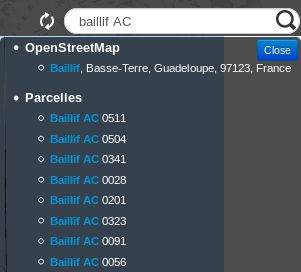
item_layer(text). Name of the layer. For example “Countries”item_label(text). Label to display the results, which is the data to search among. Ex: “France” or “John Doe - Australia”. You can build it from a concatenation of several fields values.item_project(text). List of Lizmap projects separated by commas. When set, the search will be done only for the specified Lizmap projects. The value can beNULLif you don’t want to filter per project.item_filter(text). Username or group name. When given, the results will be filtered by authenticated user login and groups. For example, ‘admins’. The value can beNULLif you don’t want to filter per user.geom(geometry). We advise to store all the geometries with the same SRID.
Here is an example of SQL code you can use, to add data from two different spatial tables into lizmap_search (here as a materialized view to ease further maintenance)
DROP MATERIALIZED VIEW IF EXISTS lizmap_search;
CREATE MATERIALIZED VIEW lizmap_search AS
SELECT
    'Commune' AS item_layer, -- name of the layer presented to the user
    concat(idu, ' - ', tex2) AS item_label, -- the search label is a concatenation between the 'Commune' code (idu) and its name (tex2)
    NULL AS item_filter, -- the data will be searchable for every Lizmap user
    NULL AS item_project, -- the data will be searchable for every Lizmap maps (published QGIS projects)
    geom -- geometry of the 'Commune'. You could also use a simplified version, for example: ST_Envelope(geom) AS geom
FROM cadastre.geo_commune
UNION ALL -- combine the data between the 'Commune' (above) and the 'Parcelles' (below) tables
SELECT
    'Parcelles' AS item_layer,
    concat(code, ' - ', proprietaire) AS item_label,
    'admins' AS item_filter, -- only users in the admins Lizmap group will be able to search among the 'Parcelles'
    'cadastre,urban' AS item_project, -- the Parcelles will be available in search only for the cadastre.qgs and urban.qgs QGIS projects
    geom
FROM cadastre.parcelle_info
;
Optimisation
You should use a table, or a materialized view, on which you can add indexes to speed up the search queries.
We strongly advise you to add a trigram index on the unaccentuated
item_labelfield, to speed up the search query:
-- Create the index on the unaccentuated item_label column:
DROP INDEX IF EXISTS lizmap_search_idx;
CREATE INDEX lizmap_search_idx ON lizmap_search USING GIN (f_unaccent(item_label) gin_trgm_ops);

-- You can refresh the materialized view at any time (for example in a cron job) with:
REFRESH MATERIALIZED VIEW lizmap_search;
Warning
At present, Lizmap PostgreSQL search cannot use 3D geometries, or geometries with Z or M values.
You have to use the ST_Force2D(geom) function to convert geometries into 2D geometries.
Configure access
Once this table (or view, or materialized view) is created in your database, you need to check that Lizmap can have a read access on it.
If your Lizmap instance uses PostgreSQL to store the users, groups and rights, a connection profile already exists for your database. Then you can just add the lizmap_search relation inside this database (in the public schema).
If not, or if you need to put the search data in another database (or connect with another PostgreSQL user), you need to add a new database connection profile in Lizmap configuration file lizmap/var/config/profiles.ini.php.
The new profile is a new jdb prefixed section, called jdb:search. For example, add the following section (please replace the DATABASE_ variables by the correct values):
[jdb:search]
driver="pgsql"
database=DATABASE_NAME
host=DATABASE_HOST
user=DATABASE_USER
password=DATABASE_PASSWORD
; search_path=DATABASE_SCHEMA_WITH_LIZMAP_SEARCH,public
You don’t need to configure the locate by layer tool. The link with Lizmap Web Client is done automatically if you can run the query below successfully in PgAdmin using the same credentials as the Lizmap application. You mustn’t specify the schema where the lizmap_search table is located. It must work without specifying the schema.
SELECT * FROM lizmap_search LIMIT 1;
You can now use the default search bar in Lizmap which is located on top right corner.
QuickFinder Plugin
Warning
This is for QGIS 2 only. This plugin has not been ported to QGIS 3.
The purpose of this plugin is to provide fast searching among big datasets, searching in a qtfs file generated by QGIS Desktop.
Prerequisites
You must have install at least the 7.x version of PHP in your Lizmap server.
Configuration
Inside QGIS:
install QuickFinder Plugin, for QGIS 2 only
choose a layer(s), define the fields to search among, pick the geometry storage format (WKT or Extent) and store Full Text Searchs (FTS) vector into a file database (.qfts). The filename must be identical to the QGIS project filename. Ex:
myproject.qftsfor a QGIS project stored asmyproject.qgs.
Warning
Only WKT or Extent formats for geometry storage are working, since binary format (WKB) can not be decoded by LWC.
Inside LWC:
put the database file beside the QGIS project, use the Search tool (input) and zoom to the chosen feature.