Base layers
Princípio
muitas vezes é útil separar temas base como uma referência e camadas temáticas num mapa Web. No Lizmap, pode utilizar grupos ou camadas como temas base. Também é possível utilizar serviços externos no mapa Web.
Os temas base não fazem parte da legenda e são apresentados como uma lista.
Nota
Se um único tema base estiver configurado (camada de projeto, serviço externo ou tema base vazio), a interface do Lizmap Web Client não mostrará a caixa de valores Temas base, mas a camada ficará visível por debaixo das outras camadas.
Configuring the tool
The Base layers tab lets you add external services as base layer and an empty base layer. The empty base layer will display thematic layers over the project background color.
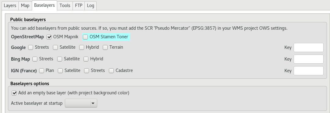
Os temas base disponíveis
OpenStreetMap, projeto de mapeamento sob licenças livres e abertas:
OSM Mapnik: serviço disponível em openstreetmap.org
ThunderForest, company using OSM data and providing tiles: * Open Cycle Map: OpenStreetMap cycling data including altitude information
Google, requer conformidade para utilizar o contrato de licença:
Streets: a camada de fundo padrão do Google Maps
Satellite: o mapa de fundo que incorpora imagens aéreas e de satélite
Hybrid: o mapa de fundo que inclui ruas e imagens de satélite
Terreno
Bing Map, requer conformidade com o contrato de licença da Microsoft e, portanto, uma chave:
Streets: a camada de fundo padrão do Bing Map
Satellite: o mapa de fundo que incorpora imagens aéreas e de satélite
Hybrid: o mapa de fundo que inclui ruas e imagens de satélite
IGN Géoportail, exige conformidade com o contrato de licença IGN e, portanto, uma chave:
Plan: A renderização IGN para Web
Satellite: o mapa de fundo que incorpora imagens aéreas e de satélite IGN
Scan: o mapa de fundo misturando a digitalização de vários IGN
Cadastre
As licenças estão disponíveis nos seguintes URLs:
Scale with external base layer
All these external base layer are provided only in EPSG:3857 / Pseudo Mercator from the provider. The scale of such layer are fixed by the projection EPSG:3857.
Aviso
As a result, if you choose an external base layer, the project will be displayed in Google Mercator EPSG:3857. Therefore, if you have specified multiple scales in the Lizmap configuration, these intermediate scales won’t be used. Only the minimum and maximum scale are used in this case. Read below about approximate scales.
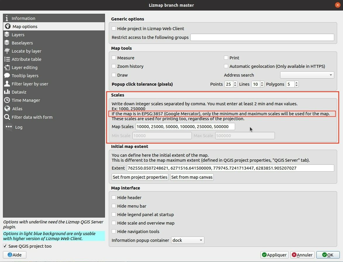
QGIS Server will perform on the fly reprojection for your data. It is therefore necessary to prepare the QGIS project accordingly.
The Google Mercator coordinate reference system must be added in the Web Services CRSs list with the .
This is a list of a very approximate integer scale for a given zoom level for the EPSG:3857:
0   500 000 000
1   250 000 000
2   150 000 000
3   70 000 000
4   35 000 000
5   15 000 000
6   10 000 000
7   4 000 000
8   2 000 000
9   1 000 000
10  500 000
11  250 000
12  150 000
13  70 000
14  35 000
15  15 000
16  8 000
17  4 000
18  2 000
19  1 000
20  500
Aviso
These scales are just a hint of the scale. It is not possible to have rounded scale like this with EPSG:3857.
Visit the OpenStreetMap website at the country level and check how the scale is changing while panning/zooming.
Camadas externas do Lizmap
This feature has been removed. It’s replaced by the possibility of using the menu , and in the plugin Layers tab declare the parent project and the Lizmap repository for the embed layers and groups. See Centralizar a cache com a integração de grupos e camadas de um projeto principal