Locate by layer — The locating tool
Princípio
A ideia desta ferramenta é apresentar ao utilizador do Lizmap Web Client uma lista de valores que oferece a capacidade de fazer zoom para um ou mais objetos espaciais da camada.
Caso de utilização
Considere uma camada espacial vetorial districts contida no projeto QGIS. Optamos por adicionar esses distritos à ferramenta Localizar por camada, para permitir aos utilizadores do Lizmap Web Client que se possam posicionar rapidamente num dos distritos.
Depois desta camada ser adicionada à ferramenta Localizar por camada, aparecerá na interface do Lizmap Web Client uma lista de valores contendo os distritos.
Quando o utilizador do mapa Web seleciona um nome nessa lista, o mapa será automaticamente reorientado para o distrito selecionado e a geometria do distrito será exibida (opcional).
Pré-requisitos
The layer must be published as WFS (see WFS/OAPI) and the primary key must be published as well in the Layer properties.
Aviso
This tool is not designed for layers having a lot of features or a lot of complex geometries. The web browser will indeed have to download all features with vector geometries so it will make the loading the application slower. To reduce the loading time, you can reduce the decimals in the WFS settings for instance if your layer is in meters. For better performance if your layer is stored in PostGIS, use PostgreSQL search.
Configuring the tool
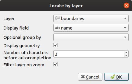
Para adicionar uma camada a esta ferramenta:
Click the
button.
escolha a camada com a primeira lista de valores da lista de camadas vetoriais do projeto
depois a coluna que contém os valores que deseja apresentar na respetiva lista
if you want to add pre-filter your data if a optional group by, use the Optional group by field.
Se desejar que a geometria dos objetos relacionados também seja mostrada no mapa quando o utilizador seleciona um item da lista, marque a opção Mostrar a geometria
If you set a value above 0, autocompletion will be used after this amount of characters while the user types. The classical combobox will be replaced by a editable text input.
If Lizmap must trigger the filter on the layer. Only the selected feature will be visible on the map.
To edit a layer in the table, select it and click the
 button or double click on the row.
To remove a layer from the table, select it and click the
 button.
To move a layer up or down, select it and click
 or
or  buttons. The order will change in Lizmap too.
Nota
If you want to display the geometry, you need to active it in , then Add geometry to the feature response.
Listas hierárquicas
Se tomarmos o exemplo dos distritos, pode ser interessante também fornecer ao utilizador uma caixa de valores concelhos. Pretende-se que, quando o utilizador escolhe um distrito, a caixa de valores dos concelhos seja automaticamente filtrada para mostrar apenas os concelhos do distrito escolhido.
Para isto, existem 2 métodos:
Either you have 2 separate vector layers: one for districts and for sub-districts. You have to use a field join between the two layers to enable automatic filtering lists in Lizmap. , see the QGIS documentation.
Or you have only 1 layer for sub-districts. You need to set, in the plugin, a group field.