Configure seu projeto para o Lizmap
Instalar o plugin Lizmap
The Lizmap plugin is available through the official QGIS project repository: http://plugins.qgis.org/plugins/lizmap/
Para instalá-lo, basta fazer como para qualquer plugin QGIS:
Search Lizmap
Instalar o plugin
Está disponível no menu e na barra de ferramentas
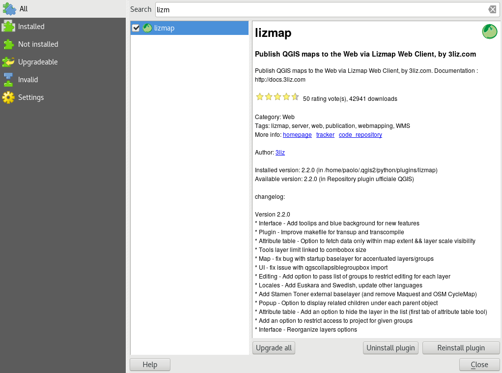
The plugin is organized in 6 tabs:
Layers: the options of each layer
Map: the general options of the map
Baselayers: the baselayers used on the Web
Tools : the Web map tools
Log: displays information of performed actions
And it has 4 action buttons:
Help
Apply
Close
Configure layers and groups
The layer configuration is done in the Layers tab.
Este separador mostra a árvore de camadas do projeto com a mesma organização definida no painel Camadas. Pode selecionar um dos elementos da árvore, uma camada ou grupo e, em seguida, configurar as opções para o grupo ou camada selecionada.
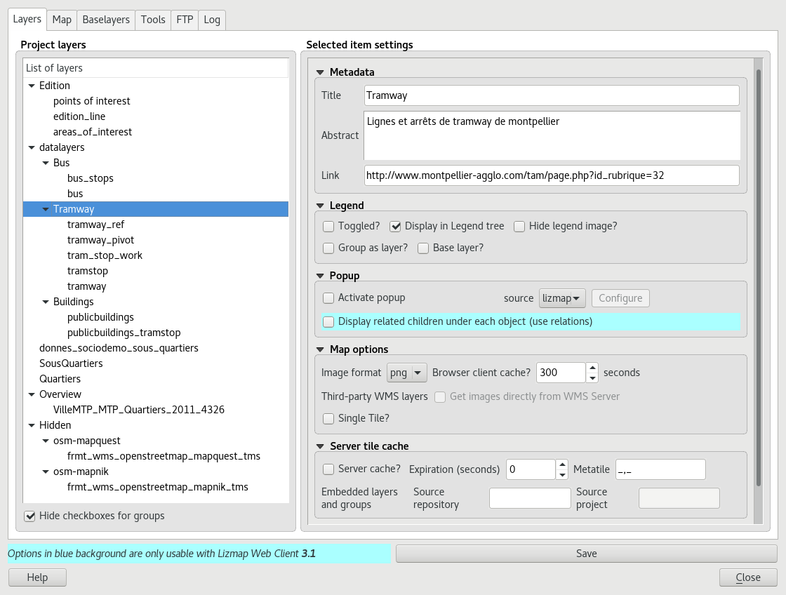
Informação sobre grupos e camadas:
Title: It will be used in the Web layers tree instead of the name. For layers, the Title Field is linked to that of the Metadata tab in the layer properties window
Abstract: It allows to describe the layer or group. It is displayed in the mouseover. For layers, the Abstract Field is linked to that of the Metadata tab in the layer properties window
Link: The web address of a document or a Web page describing the layer or group. An icon (i) appears in the legend if the link has been submitted. You can use the media folder, see Media in Lizmap.
Opções das Camadas:
Toggled: allows you to specify whether a layer is displayed by default
Activate popup: enables information popups on map’s interrogation by clicking. See How to configure popups
Hide legend image: allows you to hide the legend of the layer in the web interface
Display in legend tree: toggles visibility of the layer in the layers tree; when toggled off, it does not allow the user to manage the display of it
Base layer: sets the layer as a base map. This will be accessible via the list of basemap
Single Tile: selects the layer display mode. It can be displayed as multiple images, tiles, or a single image generated by the server
Image format:
png: full image format, full range of colors with transparency
png; mode=16bit: lighter image format, panel color restricted with transparency
png; mode=8bit: very light image format, color panel restricts to the maximum with transparency, possible degradation of the image
jpeg: light image format without transparency with loss of quality
If the layer is provided by a WMS service and that it supports the Web map Coordinate Reference System, it is possible to Directly Request images to the WMS server. This reduces the QGIS-Server load and optimize Lizmap. This option is available in the Third Party WMS layers group.
As opções de grupo:
Group as layer:
transforma um grupo numa camada única na interface web
utilizado para agrupar camadas com a visibilidade dependente da escala
simplifica a interface para os utilizadores do mapa Web
para criar um tema base a partir de várias camadas
se o grupo for uma camada, outras opções se aplicam ao mesmo.
Configure the map
The tab Map allows you to enable or disable basic Lizmap tools, choosing scales and the intial extent.
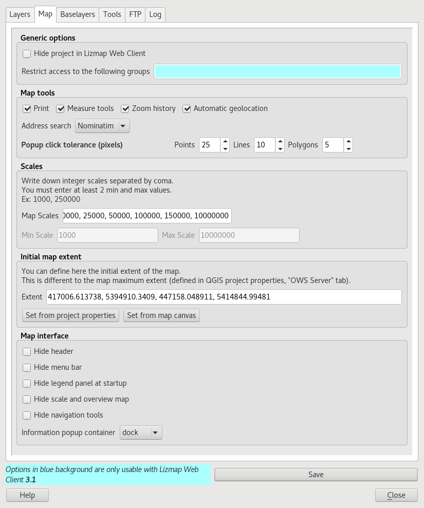
As opções genéricas:
ocultar o projeto no Lizmap Web Client:
se essa opção estiver marcada, o projeto será ocultado na página inicial do Lizmap que mostra miniaturas para todos os diretórios e projetos da aplicação. Pode utilizar essa opção para ocultar o projeto
o projeto ainda estará acessível para clientes WMS ou WFS com base em permissões sobre os diretórios
este recurso é interessante no caso de utilizar este projeto como um projeto externo para outros.
As ferramentas do mapa:
Imprimir: permite a utilização de compositores QGIS para a criação de mapas em formato PDF
Ferramentas de medição: permite utilizar as ferramentas de medição no mapa (comprimento, área, perímetro)
Histórico de Zoom: permite, através dos respetivos botões, a navegação no histórico de zoom e de movimentações no mapa
Geolocalização automática: permite que as funções utilizem a geolocalização HTML5 com base em Wifi e/ou GPS
Pesquisa por endereço: para adicionar um mecanismo de busca de endereços que se baseie num desses serviços:
Nominatim (OpenStreetMap)
Google
IGN France (Géoportail)
As escalas:
a list of integer values separated by commas (and optional whitespace), eg: 250000, 100000, 50000.
Lizmap also used these scales to restrict the display between the minimum and maximum data scales. This is why it is mandatory to enter at least 2 scales in the list.
A extensão inicial do mapa:
uma lista de coordenadas no Sistema de Coordenadas de Referência do mapa no formato: ` xmin, ymin, xmax, ymax``, definindo a extensão inicial do mapa
a extensão máxima do mapa é especificada no separador Servidor OWS da janela Propriedades do Projeto. Os dados não serão apresentados se estiverem fora dela
por padrão, a extensão inicial é a extensão máxima.
Configure the base layers
muitas vezes é útil separar temas base como uma referência e camadas temáticas num mapa Web. No Lizmap, pode utilizar grupos ou camadas como temas base. Também é possível utilizar serviços externos no mapa Web.
Os temas base não fazem parte da legenda e são apresentados como uma lista.
Nota
Se um único tema base estiver configurado (camada de projeto, serviço externo ou tema base vazio), a interface do Lizmap Web Client não mostrará a caixa de valores Temas base, mas a camada ficará visível por debaixo das outras camadas.
The Base layers tab lets you add external services as base layer and an empty base layer. The empty base layer will display thematic layers over the project background color.
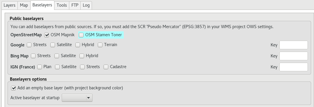
Os temas base disponíveis
OpenStreetMap, projeto de mapeamento sob licenças livres e abertas:
OSM Mapnik: serviço disponível em openstreetmap.org
OSM Mapquest: service provided by Mapquest company
Cycle Map: promotion map of OpenStreetMap cycling data including altitude information
Google, requer conformidade para utilizar o contrato de licença:
Streets: a camada de fundo padrão do Google Maps
Satellite: o mapa de fundo que incorpora imagens aéreas e de satélite
Hybrid: o mapa de fundo que inclui ruas e imagens de satélite
Terreno
Bing Map, requer conformidade com o contrato de licença da Microsoft e, portanto, uma chave:
Streets: a camada de fundo padrão do Bing Map
Satellite: o mapa de fundo que incorpora imagens aéreas e de satélite
Hybrid: o mapa de fundo que inclui ruas e imagens de satélite
IGN Géoportail, exige conformidade com o contrato de licença IGN e, portanto, uma chave:
Plan: A renderização IGN para Web
Satellite: o mapa de fundo que incorpora imagens aéreas e de satélite IGN
Scan: o mapa de fundo misturando a digitalização de vários IGN
As licenças estão disponíveis nos seguintes URLs:
OpenStreetMap: http://wiki.openstreetmap.org/wiki/Tile_usage_policy
Mapquest: http://developer.mapquest.com/web/products/open/map#terms
Nota
If you choose an external base layer, the map will be displayed in Google Mercator (EPSG: 3857 or EPSG: 900913), the scales are those of external services and QGIS-Server will perform on the fly reprojection.
It is therefore necessary to prepare the QGIS project accordingly.
The Google Mercator coordinate reference system must be added in the Web Services CRSs list with the OWS Server tab in the Project Properties window. For now, all the proposed base layers use the projection:
EPSG:3857 ; Pseudo Mercator
Here are the approximate integer scales of the current external base layers:
0   591659008
1   295829504
2   147914752
3   73957376
4   36978688
5   18489344
6   9244672
7   4622336
8   2311168
9   1155584
10  577792
11  288896
12  144448
13  72224
14  36112
15  18056
16  9028
17  4514
18  2257
Camadas externas do Lizmap
This feature has been removed. It’s replaced by the possibility of using the menu , and in the plugin Layers tab declare the parent project and the Lizmap repository for the embed layers and groups. See Centralizar a cache com a integração de grupos e camadas de um projeto principal