Tooltip — Configure the tooltip for some layers
Princípio
You can let the user activate map tooltips when hovering features by choosing a list of fields to display.
Pré-requisitos
The layer must be published as WFS (see WFS/OAPI) and the primary key must be published as well in the Layer properties.
Configuring the tool
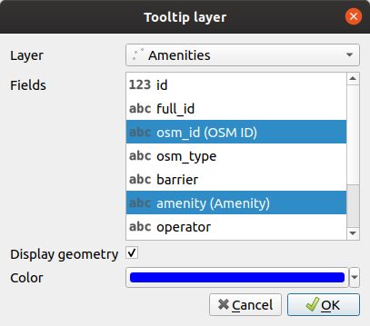
For setting a tooltip on a layer:
Click the
 button.
Choose the layer.
Select some fields to display in the tooltip.
Optionally, choose to display the geometry.
If you display the geometry, you can set the color.
To edit a layer in the table, select it and click the
 button or double click on the row.
To remove a layer from the table, select it and click the
 button.
Fields will be displayed with their alias if it’s defined. See Add a alias on a field.